2014 – 2017 | Find area to close the yield gap in agriculture
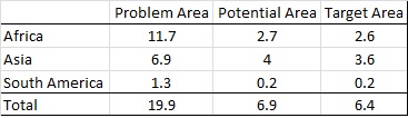
Agriculture suffers from poor yields in many parts of the world. The introduction of new seed varieties could result in higher yields and therefore in a reduction of poverty. Aim of this project was to find the geographical areas where the demand for new seed varieties is greatest while the potential for high yields is highest. To do this, spatially exhaustive information sources were selected as indicators. First the areas where seeds are needed the most were identified. These ‘Problem Areas’ are a product of the indicators poverty, hunger and yield gap. Second the areas where seeds have highest potential were identified. These ‘Potential Areas’ are a product of the indicators land suitability, crop-land and population density and climatic parameters. The methodology is described in the report: Setting the geographic scope for the Access to Seeds Index and served as input for establishing the Access to Seeds Index.
Highest impact of seed introduction is expected at hose places where the problem and potential areas spatially overlap, the so-called ‘Target Areas’ (see map below).
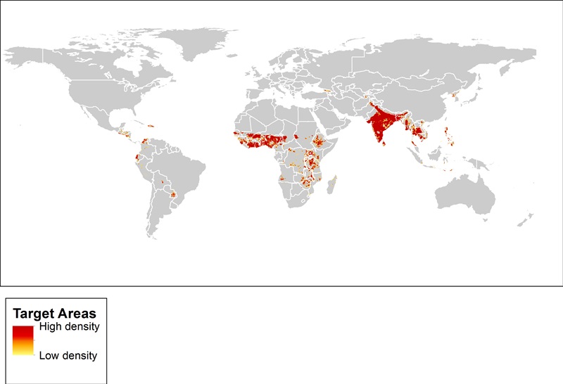
From this map, the exact areas could be calculated for each country. Globally some 6.4 million squared kilometre was identified as Target Area. There is still quite a bit of work to do!